Dredging and reclamation projects can significantly impact local ecosystems. Negative impacts can be minimised by adopting proper environmental management and mitigation, from preparation to completion phase. Addu City project sets an example of implementing novel construction methodologies and successfully addressing environmental challenges. The project has created over 200 hectares (ha) of climate resilient land for housing and touristic development. Enclosure of footprints, relocation of corals and seagrass (at pilot level) before reclamation process, and monitoring sediment impact in the nearby marine protected areas during dredging and reclamation are exemplary of the management approach applied to ensure minimisation of potential negative environmental impacts.

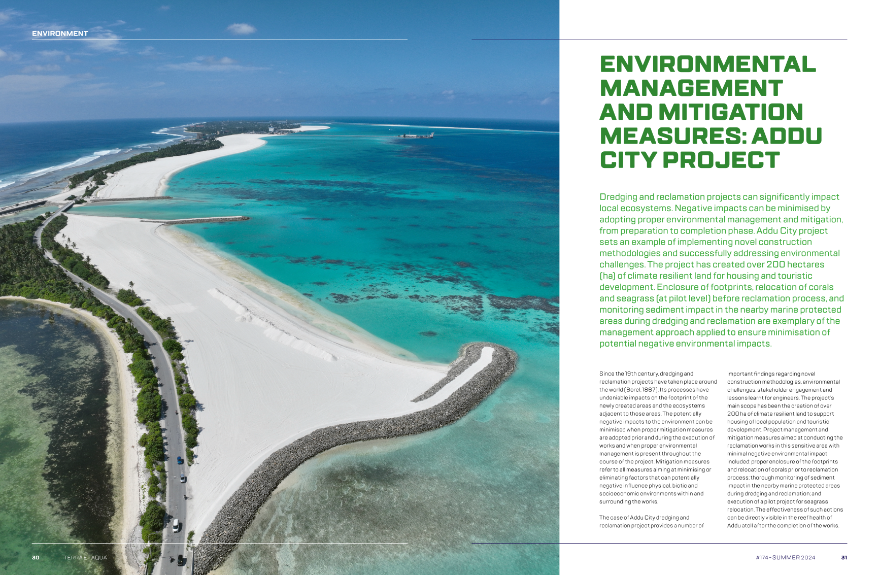
Since the 19th century, dredging and reclamation projects have taken place around the world (Borel, 1867). Its processes have undeniable impacts on the footprint of the newly created areas and the ecosystems adjacent to those areas. The potentially negative impacts to the environment can be minimised when proper mitigation measures are adopted prior and during the execution of works and when proper environmental management is present throughout the course of the project. Mitigation measures refer to all measures aiming at minimising or eliminating factors that can potentially negative influence physical, biotic and socioeconomic environments within and surrounding the works.

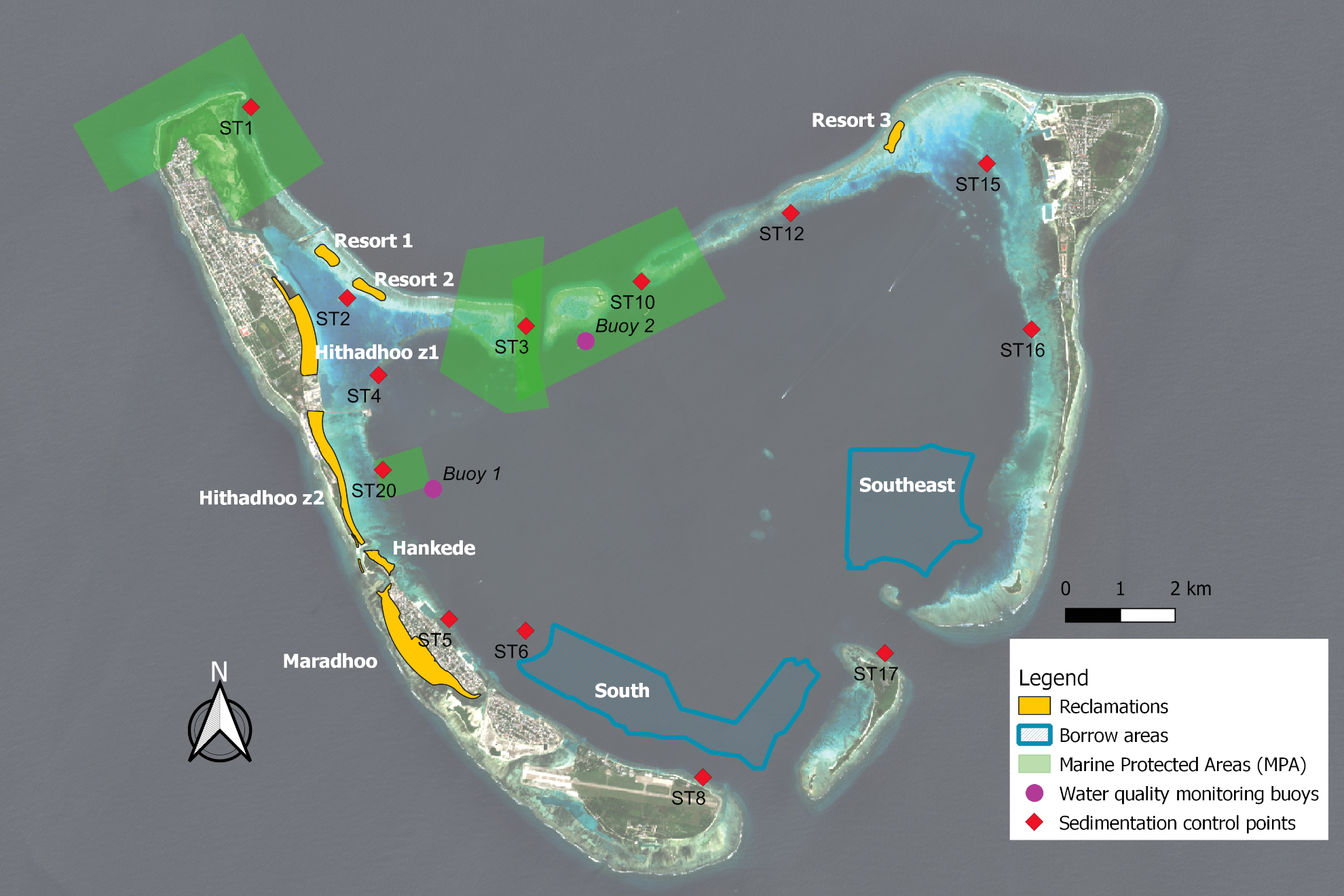
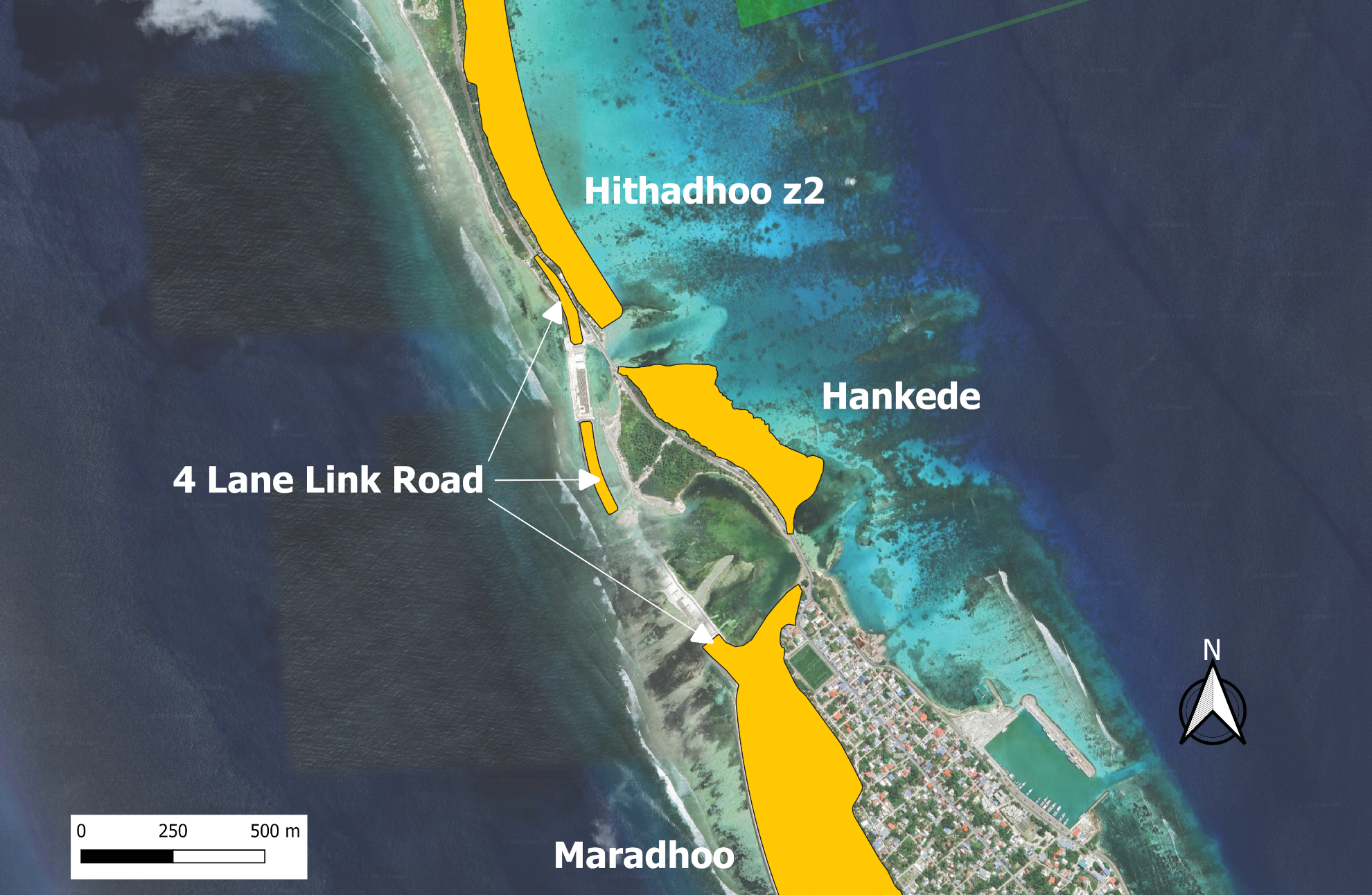
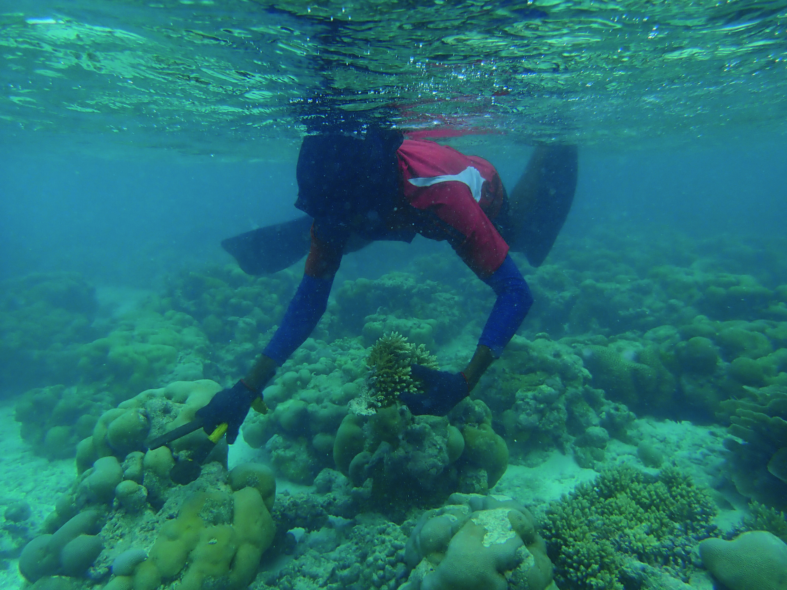
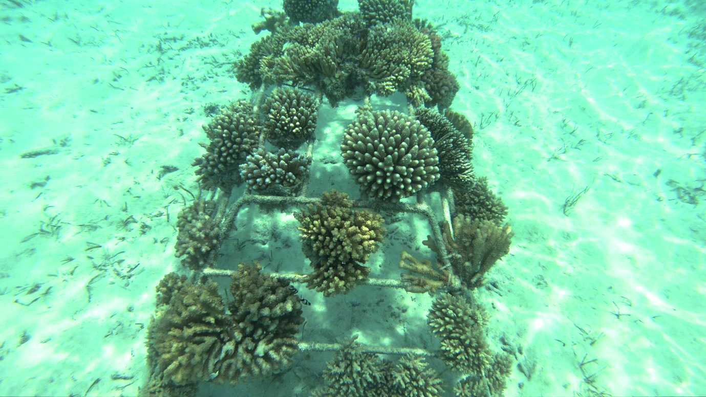
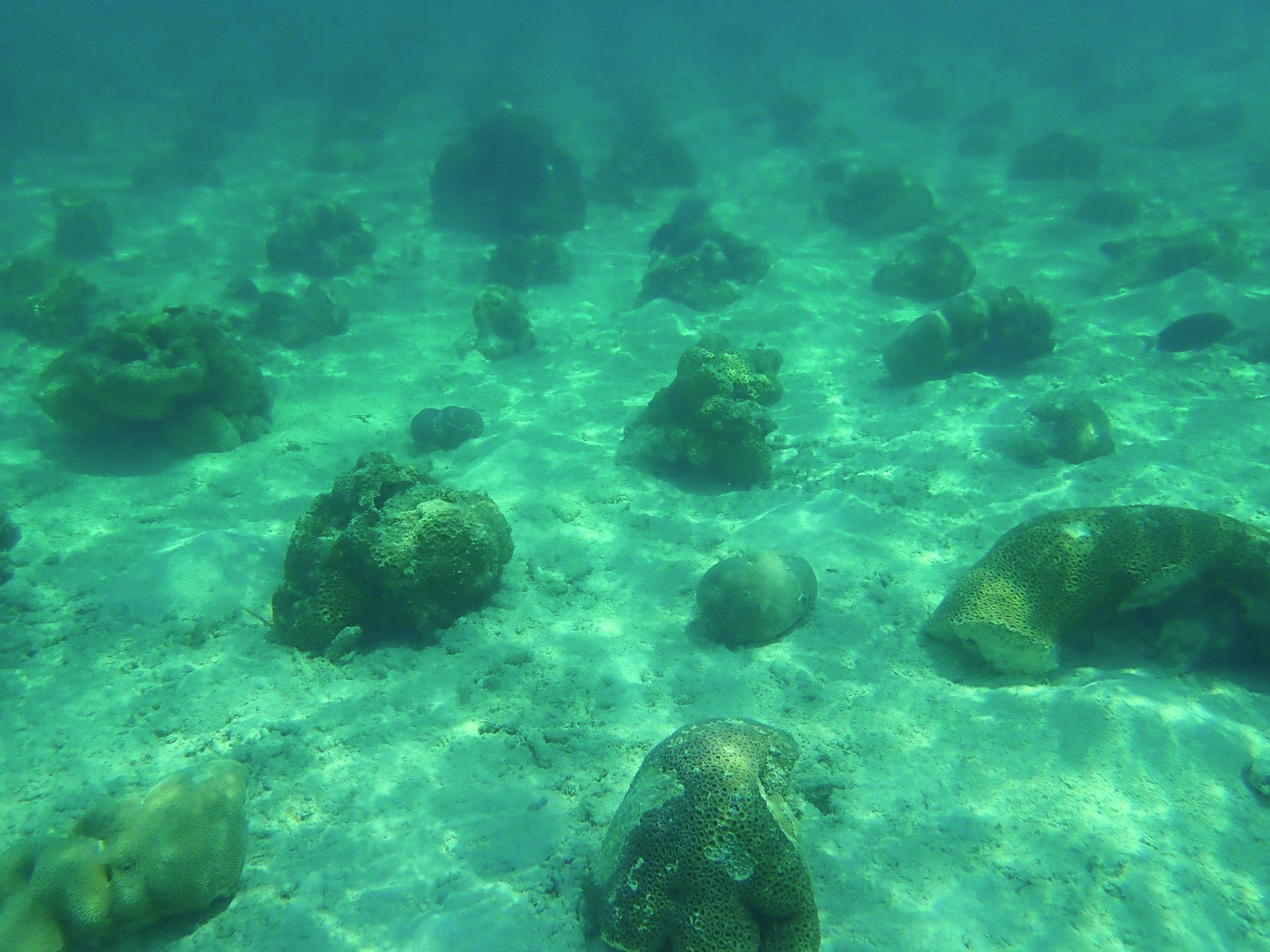
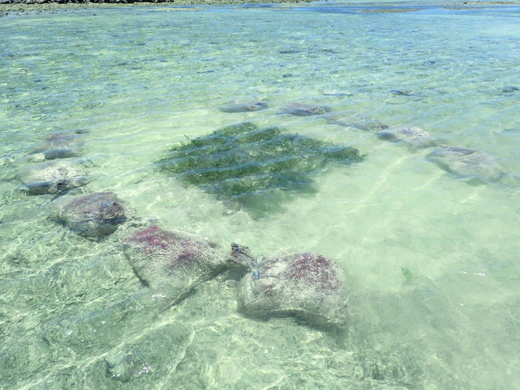
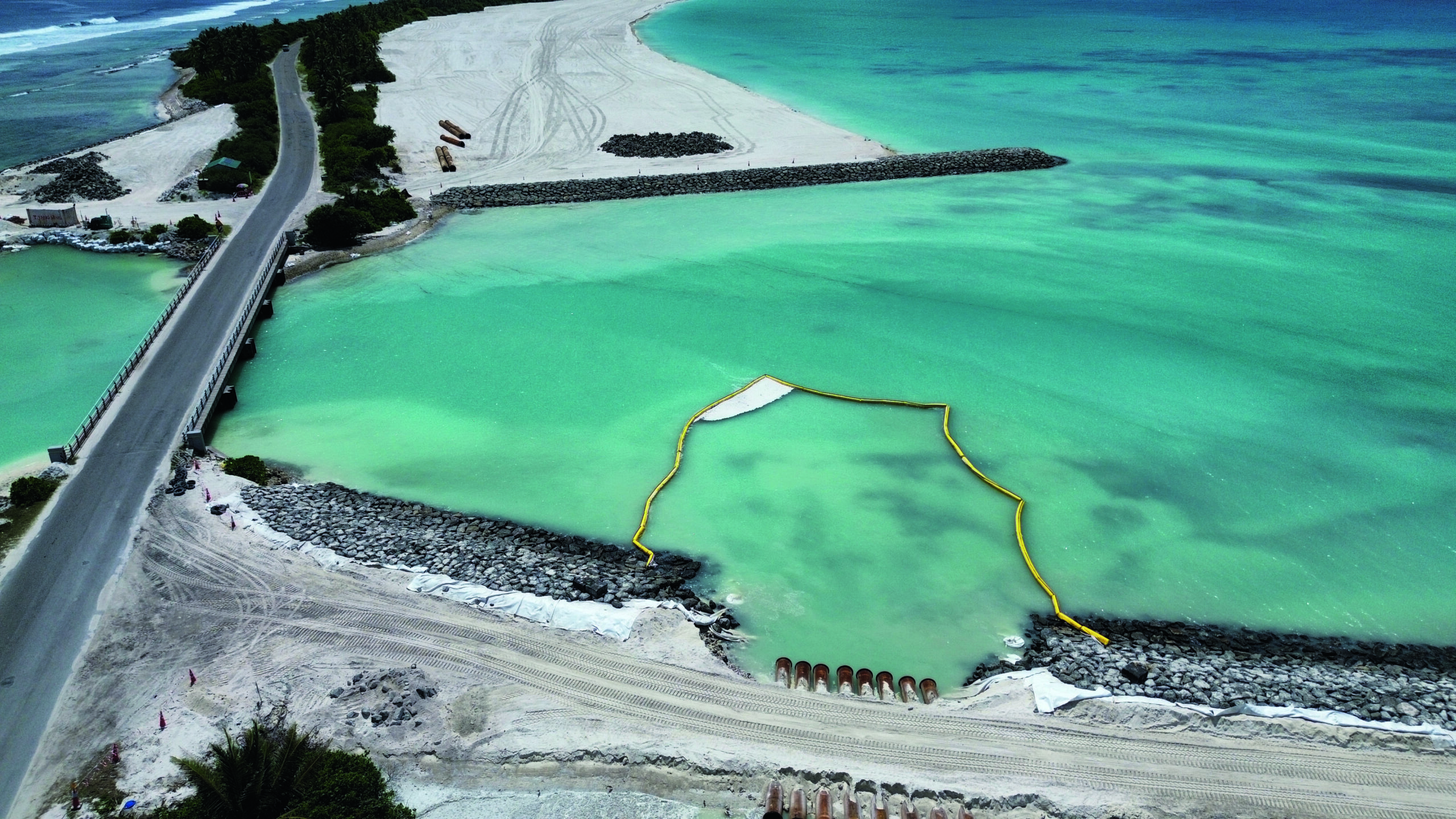
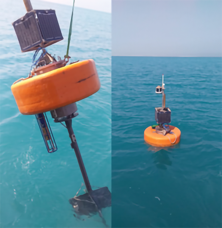
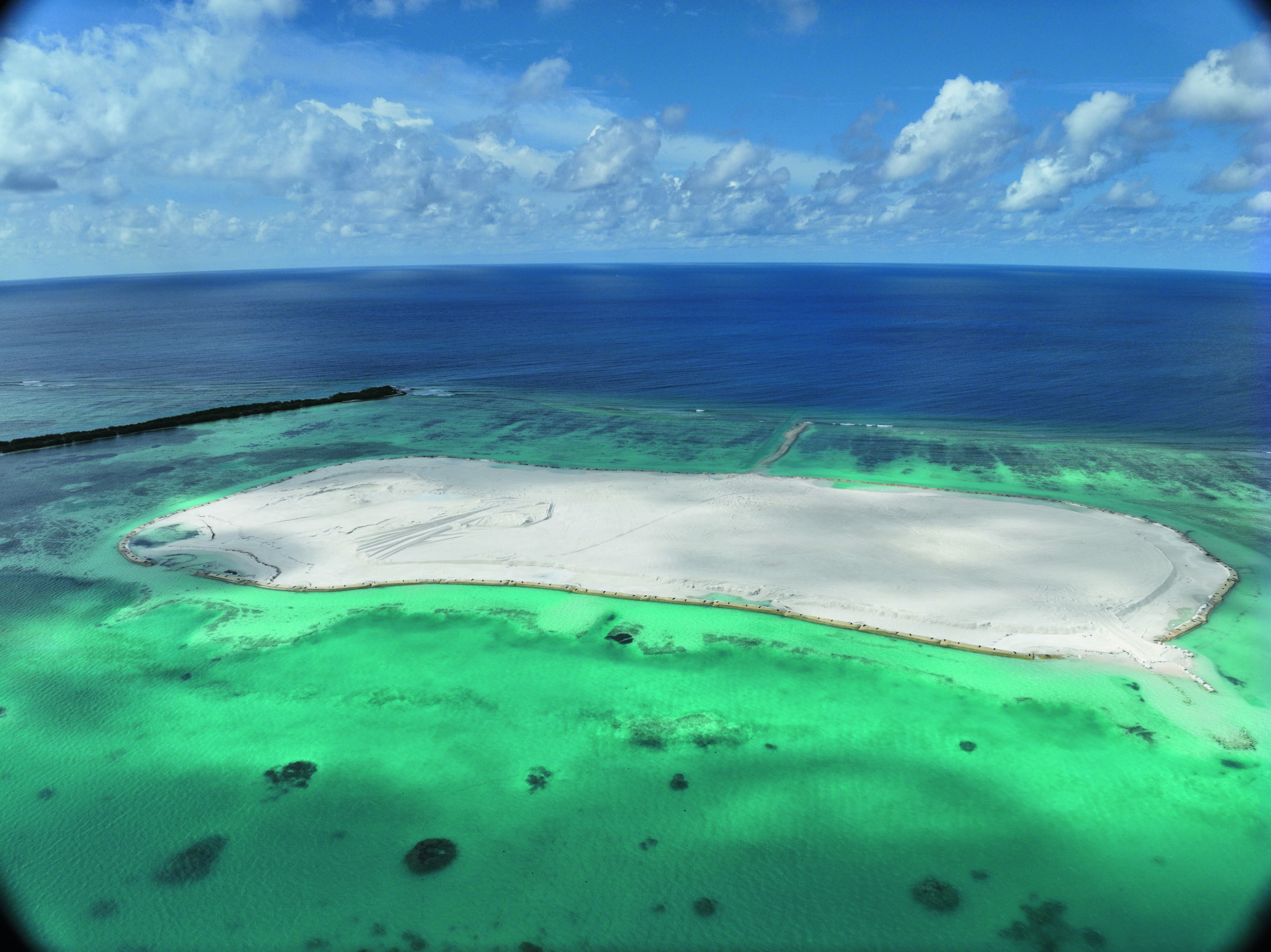
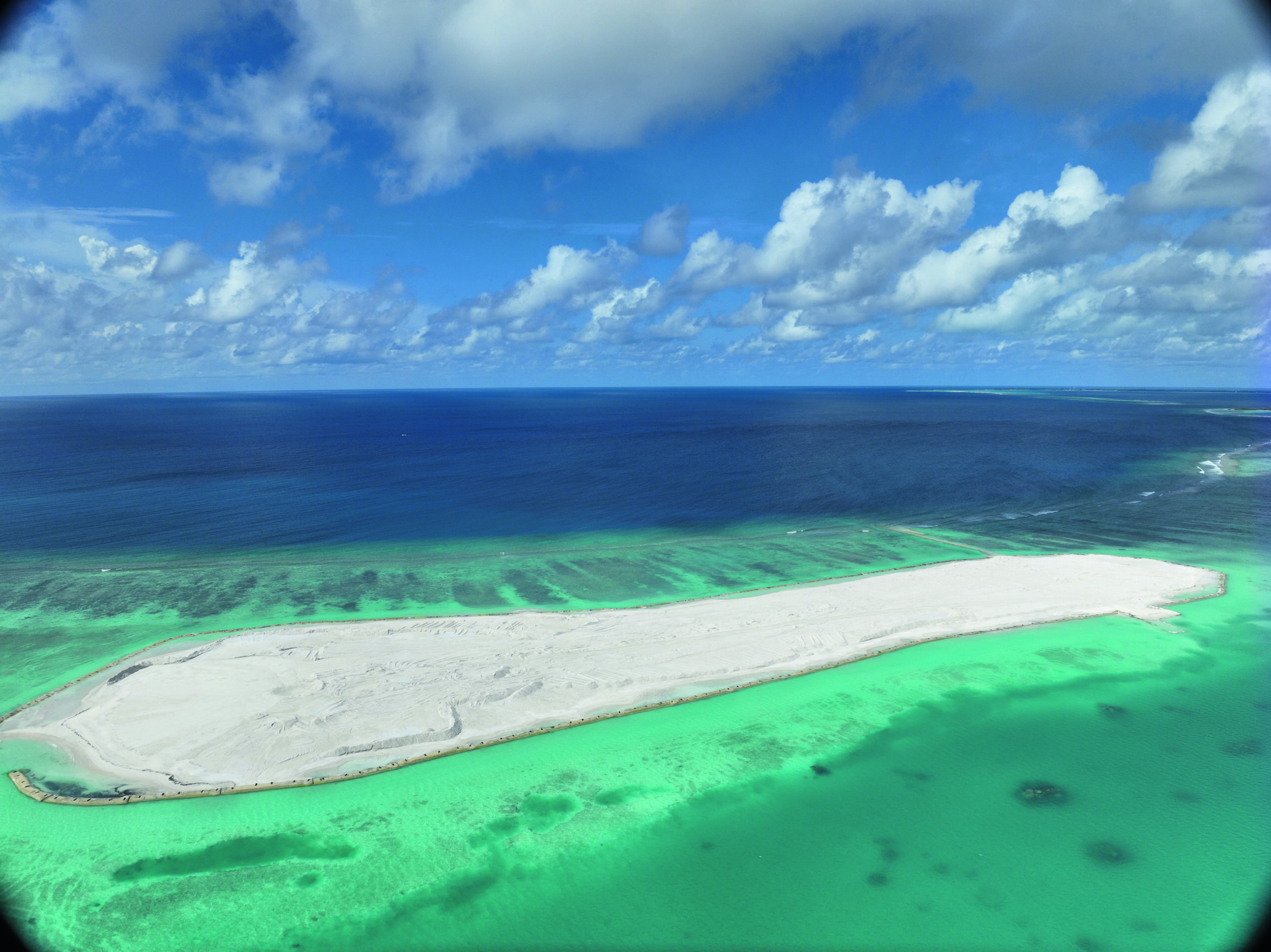
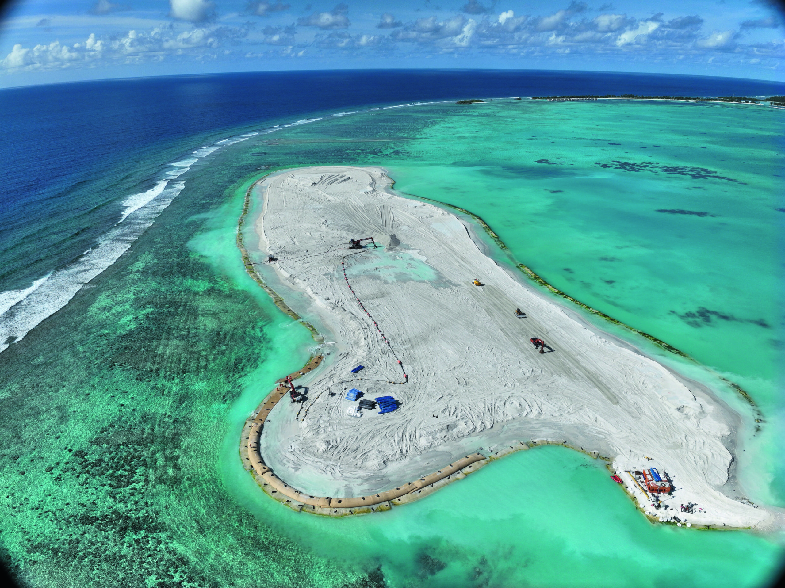
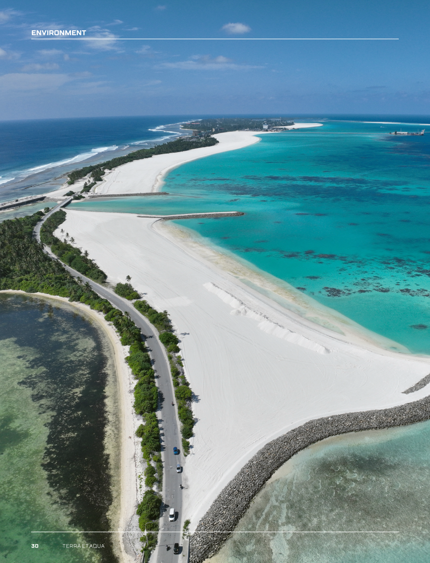
The case of Addu City dredging and reclamation project provides a number of important findings regarding novel construction methodologies, environmental challenges, stakeholder engagement and lessons learnt for engineers. The project’s main scope has been the creation of over 200 ha of climate resilient land to support housing of local population and touristic development. Project management and mitigation measures aimed at conducting the reclamation works in this sensitive area with minimal negative environmental impact included: proper enclosure of the footprints and relocation of corals prior to reclamation process; thorough monitoring of sediment impact in the nearby marine protected areas during dredging and reclamation; and execution of a pilot project for seagrass relocation. The effectiveness of such actions can be directly visible in the reef health of Addu atoll after the completion of the works.

In this article, the sequence of events along with the results of environmental actions and initiatives will be shared. The importance of a detailed and high-quality Environmental Social Impact Assessment (ESIA) will be highlighted to identify environmental challenges as early as possible in preparation. The Addu City dredging and reclamation project deployed one of the highest set of standards for management practices in a very effective manner. This approach can be adopted for projects of similar magnitude and sensitivity within and outside the region.

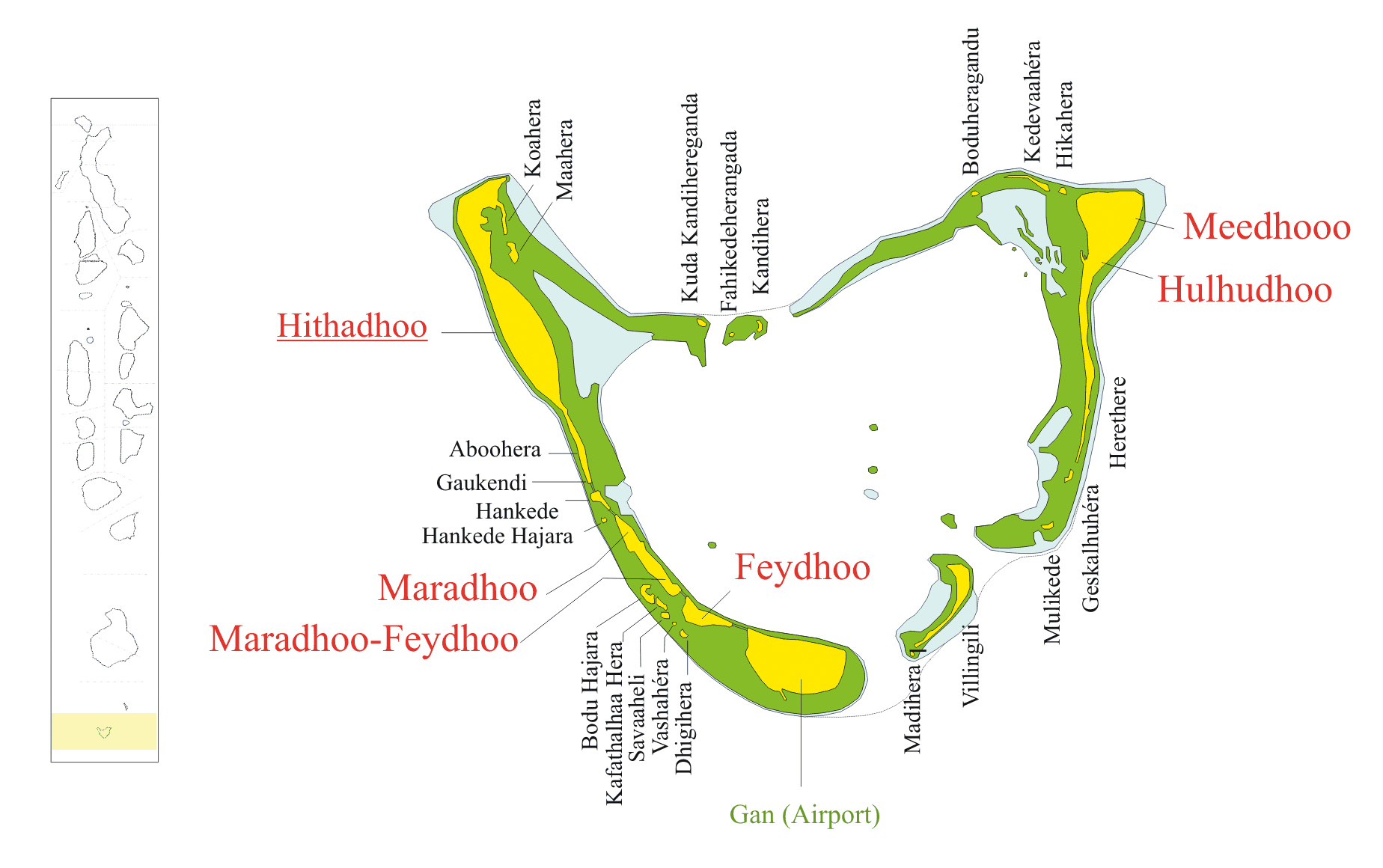
The project location


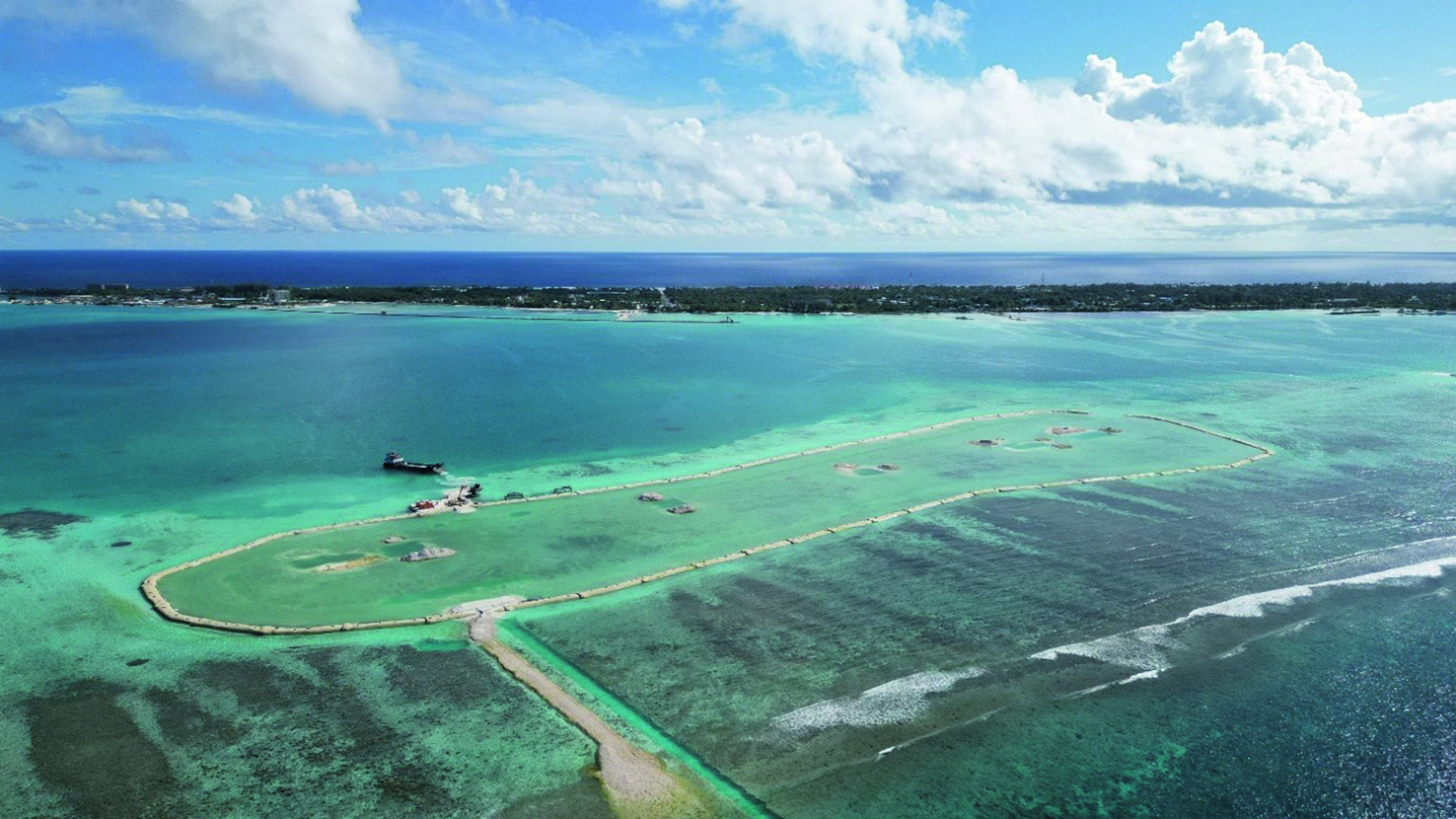
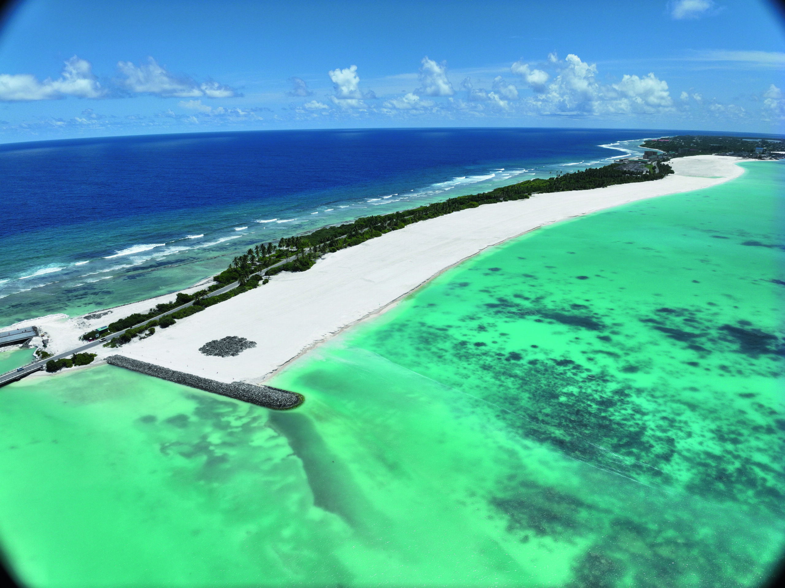
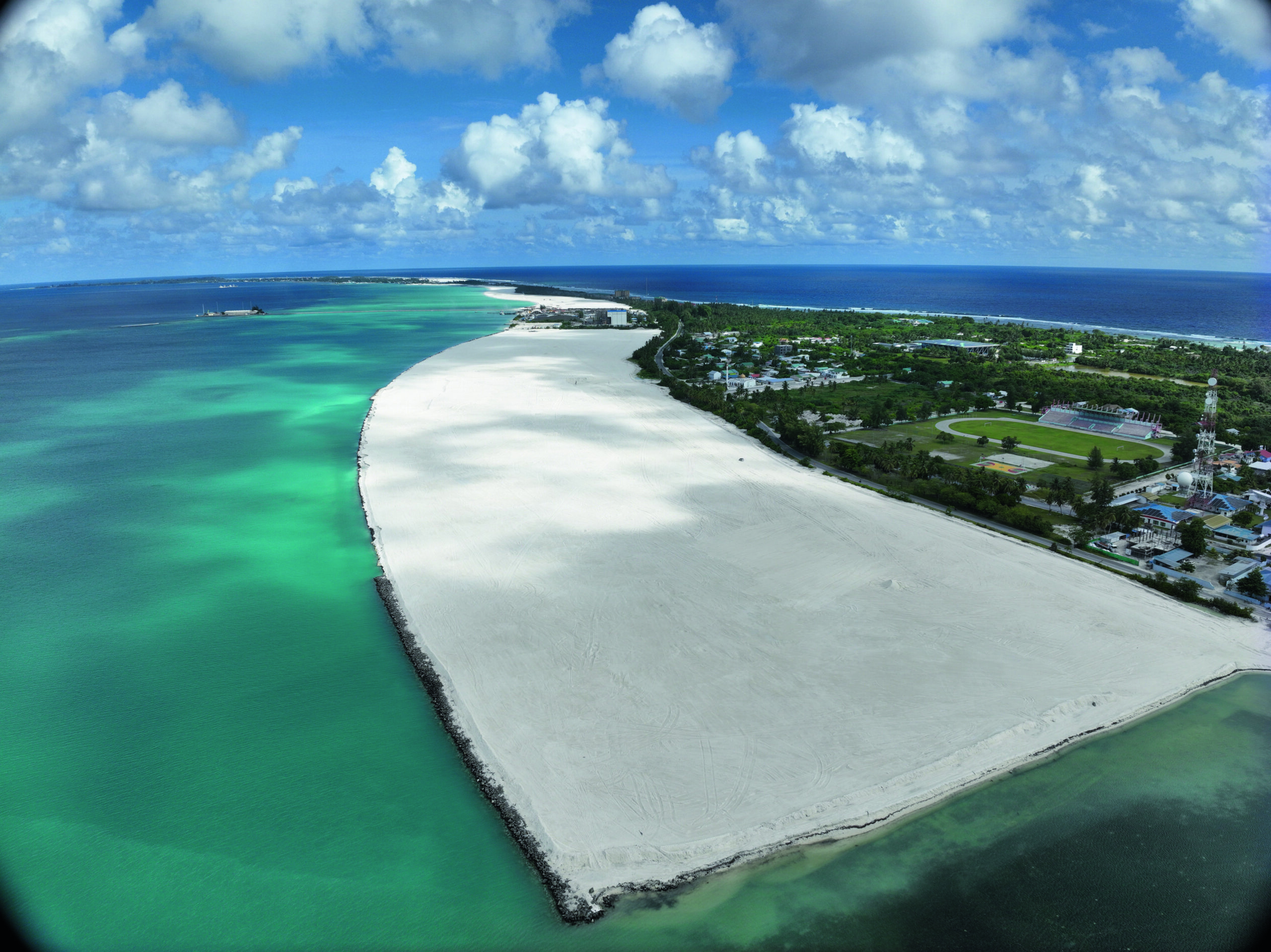
The Addu City dredging and reclamation project (referred hereafter as the project) took place in the Addu or Seenu Atoll (Figure 1). This southernmost atoll of the Republic of Maldives. Addu City consists of the inhabited islands of Gan, Feydhoo, Maradhoo, Hithadhoo and Hulhumeedhoo (Hulhudhoo-Meedhoo).

FIGURE 1

Location of the Addu Atoll in the Maldives and its islands (Ahmed, 2008).

The project description


The Ministry of National Planning, Housing and Infrastructure of the Maldives awarded the reclamation by dredging and shore protection works for land in Addu City to Van Oord. The project is part of the Addu City development project to help transform Addu City into a fully functional city, a thriving economic hub and an attractive tourist destination. To help obtain this goal, five key preconditions need to be met: stimulating the economy, tackling high unemployment, enhancing connectivity, addressing climate change and environmental protection, and promoting decentralisation. The scope of work consists of the design and construction of:

  1. Dredging and reclamation of 76 ha and shore protection works in Maradhoo;
  2. Reclamation of 90 ha and shore protection works in zone 1 and zone 2 of Hithadhoo;
  3. Reclamation of 25 ha for three island resorts;
  4. Reclamation of 4.7 ha and shore protection works in Hankede;
  5. Reclamation of 1.4 ha and shore protection works for the new four lane link road connecting Maradhoo and Hithadhoo islands
  6. Storm water drainage; and
  7. Relocation of existing utilities.

This article will focus on the strategy and execution of points 1-4, with a specific focus on the dredging and reclamation sequence, and the impact on the environment. The reclamations can be seen in Figure 2 and Figure 3. The potential impacts of the project are described in the Environmental and Social Impact Assessment (ESIA) of the project (Water Solutions, 2022).

FIGURE 2

General outline of the reclamation project in Addu City.

FIGURE 3

Focus on the area of the Hankede island indicating the abutments for the new four lane link road.

Dredging equipment


The dredging and reclamation was executed by the trailing suction hopper dredger (TSHD) HAM 318 with hopper capacity of 39,467 m3, two suction pipes of 1,200 mm and maximum dredging depth of 135 metres (Van Oord, 2016).

The vessel is capable of under-keel overflow and is equipped with an environmental or green valve (PIANC, 2010). The environmental valve is a butterfly valve in the overflow system of the TSHD aimed at reducing the formation of air bubbles in the overflow mixture. This results in more stability of the near-field overflow plume, which increases the settling of the generated plume on the seabed. This way the spatial extent of the plume is significantly reduced keeping it close to the dredging area.

FIGURE 5

The trailing suction hopper dredger HAM 318 in Addu City, Maldives during reclamation of Hithadhoo zone 2.

Sequence of execution of works


Preparatory works

Preparatory works include every activity preceding the main volume of the construction process, namely the dredging and reclamation works. Those works include mobilisation of personnel and equipment on the construction site. They also include the bathymetric survey of the existing condition of the project area prior to any construction process.

Furthermore, with regards to the environmental aspects of the project, the preparatory works include all the required surveys assessing the marine life and existing environmental conditions in the project area. In further detail, those surveys include:

  • Marine ecology surveys assessing benthic life and marine species on the reclamation footprint and adjacent areas.
  • Environmental monitoring surveys assessing the prior-to-dredging conditions on water quality, temperature, sedimentation, air and noise quality.

A selection of corals from the reclamation footprints needs to be transferred to suitable recipient sites. Van Oord, with the support of a local sub-contractor has performed coral relocation pre-survey in July 2022 to assess quantitatively and qualitatively existing coral reefs within reclamation footprints (see Figure 5) and immediate vicinity. Moreover, an assessment of potential recipient sites within Addu Atoll was made. Those sites should have the same or similar environmental conditions to ensure that corals will survive and grow in the new environment. The results of the pre-survey were used to identify number, species and type of donor corals and the most suitable recipient site for each category of donor corals.

FIGURE 5

Corals collected within the reclamation footprint of island resort 3 during coral relocation works.

Construction works prior to dredging and reclamation


Construction of enclosures of the reclamation footprints

This part of the works includes the proper enclosure of the reclamation footprints. This requirement stems from the environmental impact assessment mitigation measures to contain the high turbidity levels expected during reclamation. For that purpose, depending on the design strategy for each footprint, the enclosure consists of:

  • Sand bunds, in case the final reclamation is expected to have a form of a beach. Such footprints include the Hithadhoo zone 2 and Hankede (Figure 6) reclamations.
  • Sand and rock bunds up to the reclamation level, in case that coastal protection works have been foreseen. Such footprints include Maradhoo and Hithadhoo zone 1 (Figure 7) reclamations.
  • Sand-filled geotextile tubes for creating the outline and the coastal protection of the resort islands 1, 2 (Figure 8) and 3 (Pilarczyk, 2008). The coastal protection consists of two layers of geotextile tubes and the enclosure of the footprint has been implemented by installing the first layer of the geotextile tubes.
FIGURE 8

First layer of geotextile tubes for the enclosure of resort island 2 reclamation footprint (01/06/2023).

Implementation of coral relocation works

Another mitigation measure arising from the ESIA has been the relocation of a selection of corals from the reclamation footprints to suitable recipient sites. Therefore, after the completion of the marine ecology and environmental monitoring surveys, and the preparatory works for the coral relocation, an elaborate plan for relocation of corals from the reclamation footprints was implemented. These corals were transported to safe recipient sites within Addu Atoll. The recipient sites were chosen based on ecological, recreational, educational and cultural criteria.

Van Oord appointed three local dive groups with marine biologists to execute this task of relocating more than 73,000 coral colonies within the provided timeline of the project. The relocation works lasted a total of three months. The sub-contractors removed coral colonies from the reclamation footprints using hand tools, such as a hammer and chisel. The detached corals were then safely transported by boats to nearby selected recipient sites. Detached corals were categorised based on their growth forms: fragile coral colonies were placed on frames (Figure 9) whereas massive and sub-massive coral colonies were placed freely on the seabed (Figure 10) or fixed using a cement mixture.

FIGURE 9

Fragile corals placed on frames at recipient sites.

FIGURE 10

Corals placed on seabed in recipient sites.


Implementation of seagrass pilot

Even though the ESIA indicated that the project will have an impact on the seagrass meadows, no mitigation measures were imposed. However, Van Oord implemented a seagrass pilot programme relocating a total of 640 seagrass sods of 0.125 m2 from the reclamation footprint of Maradhoo, to three specifically chosen locations nearby Feydhoo. Van Oord has worked closely with local stakeholders to replant those sods in different patterns (see indicatively Figure 11) to examine the survivability of the pilot programme and to scale it up in future endeavours.

FIGURE 11

Replanted seagrass in wave active sites has been protected with hessian bags filled with rock.

Monitoring scope and additional mitigation measures during dredging and reclamation


Silt curtains

Silt curtains are arrangements designed to control suspended solids and turbidity generated in the water column as a result of environmental dredging operations and navigation. The Ecocoast Ecobarier Silt Curtains ESC-300 type III were chosen for the project. This type of silt curtains is suitable for nearshore application, for moderate to strong tidal flows (<1.5 m/s), for moderate exposure waves (<1.5 m) and medium to long project duration. Those technical specifications are consistent with the tidal and wave conditions within Addu Atoll and with the project duration. Installation, (re-) handling and anchoring has been implemented according to the specifications of the supplier (Ecocoast, 2020).

Figure 12 shows the installed silt screen at Hankede reclamation. The outfalls consist of 8 pipes of 1 m diameter. The silt screen is placed around those pipes to further contain dispersion of sediments further away from the immediate vicinity of the reclamation outfalls. This limits the negative impact of sediment induced turbidity clouds originating from the reclamation works onto the coral reefs within the atoll. It is anticipated that the amount of suspended fine sediments that the silt screen would need to prevent from spreading increases as the reclamation filling progresses. As an indication, the turbidity just outside of the silt screen in Hankede was measured with a water quality EXO3 probe on 3 August 2023, one day prior to the completion of Hankede reclamation. The exact location of measurement was the water column in front of the groyne located in the south of Hithadhoo zone 2 reclamation (Figure 12), 85 m from the silt curtain. Spot measurements on this location indicated turbidity of 37.53 ± 0.02 NTU, whereas the turbidity in the buoy in the British Loyalty Shipwreck did not exceed 3 NTU within the following days. It is safe to consider that the sediment that managed to pass the silt screen was deposited relatively fast, due to the low current speeds in this particular location.

FIGURE 12

Installed silt screen for the Hankede reclamation and the south groyne of Hithadhoo zone 2 reclamation.


Adaptive sediment management plan

An adaptive sediment management plan is a set of actions taken during the active phase of dredging to ensure that no exceedances of turbidity limitations occur or if they do, that they remain under control. There is a set of measures that can be adopted, which are divided in two categories: proactive management including the measures that are taken when level 1 triggers are exceeded; and responsive management including the measures taken when level 2 triggers are exceeded.

The strategy followed for this plan is based on the approach used within the Building with Nature research group on adaptive management strategies. Adaptive management was also selected as a management practice applicable to the project during the PIANC 100 Workshop.

Among the measures applied to the project, the proactive management actions include:

  • Continuous collection of data from both reactive and informative monitoring programmes to generate useful datasets.
  • Recording all relevant environmental management actions carried out.
  • Analysing all data and reporting to look for optimisation possibilities.
  • Adapting work methods to optimise environmental and dredging performance.

Moreover, responsive management actions include:

  • Reviewing the origin of trigger level exceedance and select most appropriate management practices.
  • Investigating the expected effect of selected management practices.
  • Preparing implementation plan and procedures.
  • Confirmation that implementation of management practices is still required.
  • Implementing management practices.
  • Prioritising reactive (water quality) monitoring to measure the effects of implemented management practices.
  • Informing stakeholders of exceedance and responsive actions taken.

Monitoring scope

A series of monitoring campaigns were implemented prior, during and after the execution of the dredging and reclamation works. It was important to minimise the impact of the dredging works in the local marine environment. In addition, temperature, pH, turbidity and sedimentation are parameters that needed to be monitored to ensure that no exceedances beyond the regulated limitations occurred. Furthermore, the local marine environment should be frequently inspected to investigate whether the dredging and reclamation works have no impact to the marine life, namely coral health, fish abundance, protected species, etc. Those requirements are indicated within the ESIA of the project (Water Solutions, 2022).

The means of monitoring turbidity throughout the project include floating buoys. The buoys were installed in the project area (as shown in Figure 2) at locations in the marine protected areas that were expected to be affected by the project’s works.

The buoys are equipped with an EXO3 Multiparameter sonde (referred to as sensor). The sensor is placed under the water surface and the measured data is collected in the buoy and transmitted to the office by means of a GPRS connection. Secondly, the data is stored in the buoy datalogger and can be downloaded to a computer using a serial USB link. The major components of the water quality monitoring buoy are indicated in Figure 13. The datalogger is equipped with a GPS receiver for timing and tracking of the buoy. Additionally, the monitoring buoys are equipped with a strobe light and a radar reflector for detection. The sensor is connected with the controller (data processor) in the instrument barrel with an individual sensor cable. The controller uses the GPS for timing and position. The turbidity sensor measures turbidity levels every minute and logs the observations in the controller. Accordingly collected data is transmitted every 15 minutes to the office. The buoys are capable of measuring turbidity, pH and water temperature continuously.

FIGURE 13

Left: water quality monitoring buoy showing the solar panels, the underwater connectors, the floater (orange), the water quality EXO3 sensor, the buoy tail and resistance cross. Right: deployed monitoring buoy showing (above the solar panels) the radar reflector, the solar panel charged light and the antenna.

The total suspended solids can be indirectly calculated based on the turbidity measurements using a conversion coefficient. The conversion coefficient depends on the composition of the sediment. Consequently, sediment samples were taken from several locations within the Addu Atoll. The correlation coefficient between turbidity [NTU] and total suspended solids (TSS) [mg/l] was calculated at 1.512.

The Environmental Protection Agency of Maldives indicated that the maximum values of turbidity are 3-5 NTU in the MPA and for sedimentation rate 15 mg/cm2/day in specifically chosen locations within the inner atoll. It has to be highlighted however, that as indicated by PIANC (2010) in report number 108, “Dredging and Port Construction around coral reefs”, exposure to turbidity and sedimentation rate of levels higher than the indicated limits needs to last weeks to cause stress to corals. Consequently, short- term exposure to slightly higher values of turbidity and sedimentation rate is not expected to affect the coral health.

Based on the measurements acquired from the monitoring buoys, there have been no significant modifications in the background values of pH and water temperature throughout the dredging and reclamation period. Moreover, the combination of enclosing the reclamation area and installing silt curtains around the reclamation outfalls to contain turbidity levels further from reclamations, has resulted in maintaining daily average values of turbidity below 5 NTU or 7.56 mg/l, if the correlation coefficient is applied. Exceedance was only recorded within the last two days of dredging and reclamation at 6-8 NTU. This is attributed to a swell event entering from the east side of Gan island and resulted in transporting the dredge-induced plume towards the buoy at the British Loyalty Shipwreck. Nevertheless, the duration of the exceedance was too short to have significant impact on the coral health and marine life.

Measurement of sedimentation rate has been achieved by means of installation of sediment traps in specific locations within Addu Atoll indicated by the ESIA (see Figure 2). The location was chosen in order to monitor the sedimentation rate along the reefs within Addu Atoll and have a more extensive overview of the sediment transport throughout the active phase of dredging.

Sediment traps have been constructed by 5 cm internal diameter PVC pipe, 11.5 cm long and sealed at the bottom end, with baffles at the top of the pipe to prevent entry of fish. Each set of traps consisted of three traps tied together to an iron stake driven to the seabed, approximately 20 cm from reef bottom (see Figure 14). At each site, three sets of traps were deployed between 5 and 10 metres, for a duration of 14 days. Retrieved sediments are washed in freshwater multiple times to remove salt and then oven dried at 60° C and weighted to 100th of a gram. Sedimentation rate is calculated as mg of sediment per cm2 per day, as the ratio of the sediment weight (total dry weight of the sediment samples from each site) divided by the product of the number of days of deployment and the area of sediment deposition.

FIGURE 14

Example of sediment trap (English etal., 1997).

Construction works during dredging and reclamation


Dredging and reclamation sequence

As indicated in Figure 2, the TSHD HAM 318 can remove sediment from two borrow areas, namely the south and the southeast borrow areas. A dredging cycle of the TSHD consists of dredging from one of the borrow areas up to accumulating the maximum volume of hopper capacity. Then, the sediment is deposited in the reclamation footprints by means of a floating pipeline.

Each of the trips of HAM 318 are shown in Figure 15 throughout the course of the dredging and reclamation phase of the project

FIGURE 15

Gantt chart for the sequence of dredging and reclamation of the project.

The reclamation in Hithadhoo zone 2 took place in several stages as indicated in Figure 16 due to its elongated shape, to accommodate the unobstructed execution of reclamation works and to accommodate the function of the Hithadhoo commercial port. Thus, Hithadhoo zone 2 reclamation started on 28 May 2023 and was completed on 1 August 2023. The floating pipelines were installed on the southmost and the northmost locations of the footprint, whereas the reclamation outfalls were placed in the middle of the length of the reclamation, close to the marine protected area of the British Loyalty Shipwreck. The choice of the outfalls aimed at accommodating the efficiency of the reclamation execution. Even though the distance from the MPA is substantially small, the use of silt screens combined with the placement of an environmental buoy in the MPA (Figure 2) resulted in a thorough monitoring of the reclamation process and ensured that no turbidity exceedances were recorded within the British Loyalty Shipwreck area.

FIGURE 16

Reclamation at Hithadhoo zone 2 on 14 August 2023, with groyne constructed in the south of the reclamation and the natural beach started forming in the inner side of the atoll.

Maradhoo reclamation was implemented between 31 May and 25 June 2023 (see Figure 18). The floating pipelines were placed from the inner atoll, crossing over the main street and discharging sediment mixture from the north (see Figure 17) and the south side of the reclamation, whereas the reclamation outfalls were placed midway in the enclosure sand and rock bund. The floating pipelines were protected with road humps made of sand, so that the reclamation could proceed according to plan and the traffic through Maradhoo-Feydhoo, Maradhoo and Hithadhoo islands remain unobstructed. As shown in Figure 17, an intermediate bund was constructed across the reclamation area to further assist in fine sediment containment from the offshore side of the atoll. Since the outfalls are placed in the offshore side of the reclamation, there was no possibility of using silt curtains for sediment containment in the last stage of the reclamation. However, the strong currents ensured that no sediment plume could possibly form.

FIGURE 17

Maradhoo reclamation footprint progress on 12 June 2023 (floating pipeline discharging sediment mixture from the north).

FIGURE 18

Maradhoo reclamation footprint on 14 August 2023 (drone photo taken from the north edge of the reclamation). The location on the north side where the floating pipeline cross the main street is indicated with red box.

Hithadhoo zone 1 reclamation was executed between 1-17 July 2023. The floating pipeline was installed from the south side of the reclamation. It must be highlighted that this was the first reclamation completed with sediment taken entirely from the southeast borrow area, whereas Maradhoo and Hithadhoo zone 2 were filled by sediment coming both from south and southeast borrow areas. This is part of the general strategy to periodically switch borrow areas to control the sediment dispersion and the plumes generated locally due to the dredging operations. The reclamation outfall was placed in the midway of the rock bund enclosure and silt screens used to ensure containment of sediment dispersion further from the reclamation area.

FIGURE 19

Hithadhoo zone 1 reclamation on 13 August 2023 (drone photo taken from the north side of the reclamation).

Resort islands 1 and 2 reclamations took place 18-23 July 2023 and 26-29 July 2023, respectively. Resort island 1 was filled with sediment from southeast borrow area, whereas resort island 2 was filled with sediment from south borrow area, once again to maintain low turbidity generated by the dredging operations. As previously indicated, the enclosure of the reclamation footprint was accomplished by sand-filled geotextile tubes. The final design of the islands included two layers geotextile tubes, one placed on top of the other. The enclosure was made by installing the first layer of the lower tubes. However, in the circumference of the enclosure, one geotextile tube in the west/ southwest of the islands was not placed to serve as the reclamation exit, which was covered by silt screens. The resort islands 1 and 2 after the completion of the reclamation procedure can be seen in Figure 20 and Figure 21, respectively.

FIGURE 20

Resort island 1 reclamation on 13 August 2023 (drone photo taken from the south of the island). In the southwest of the island the opening used as the reclamation exit can be seen.

FIGURE 21

Resort island 2 reclamation on 13 August 2023 (drone photo taken from the south of the island). The opening used as reclamation exit is visible in the west of the island.

Final stage of the reclamation sequence has been the execution of the resort island 3 (Figure 22) and the Hankede (Figure 23) reclamations. The enclosure of the resort island 3 consists of geotextile tubes whereas Hankede consists of sand bunds. Those reclamations collectively were executed between 1-7 August 2023. The major reason for this choice was that for resort island 3, even after creating the enclosure, it was not constantly above water. Thus, the only possibility of executing a closed reclamation, where the sediment mixture would stay within the area of the island would be if the reclamation took place during low tide. The rest of the time, sediment mixture was placed in Hankede reclamation. Silt curtains were used here as well to contain sediment dispersion.

FIGURE 22

Resort island 3 reclamation footprint on 14 August 2023 (drone photo taken from the west of the island). In the lower left of the photo you can see the second layer of geotextile tubes being installed.

FIGURE 23

Hankede reclamation completedon 14 August 2023.

Discussion and lessons learnt


The information contained in the above clearly supports the argument that environmental management was present throughout the entire course of the project. The environmental manager is always responsible for performing inspections of processes and equipment to avoid any accidental situations (oil spills, damage to coral reefs etc.). It is also within the responsibilities of the environmental manager to inform local community (city councils, NGOs, etc.) about progress updates and record concerns and feedback that need to be addressed in every phase of execution.

Prior to the reclamation, the initial phase of construction is strongly dependent on the site conditions. In addition, there is a need to minimise the impact of construction equipment so that minimal social obstruction occurs, i.e. no obstruction of transportation of goods and people or fishing activities. Moreover, it is essential to ensure minimal impact on marine life due to the execution of works. Construction with minimal noise and turbidity effects will contribute minimal impact to the marine life. Prior to enclosure of the reclamation footprints, the removal of marine life is highly important and requires timely use of resources (workers, equipment, local community) to work together. Another responsibility of the environmental manager to coordinate.

During execution of dredging and reclamation, rapid response to potential exceedances of monitoring parameters (turbidity, sedimentation, air and noise quality, etc.) is of high importance. If action is taken as soon as possible, then the reversing of the impact on the environment will also be fast. Thus, the environmental manager is always in direct contact with the managers of all other project departments including operations and health and safety.

A direct result of proper environmental management was visible after the completion of the dredging and reclamation works. Not only has marine life not been affected within the marine protected areas, but also in Addu Atoll in total. A significant highlight has been the observation of manta ray sightings during the project. Sighting incidents of manta rays (as shown in Figure 22) were recorded based on information provided by local dive masters, indicating that this magnificent marine life species kept returning every day at the Maa Kandu Manta Point (marine protected area indicated in green polygon around buoy 2 at Figure 2).

Finally, the importance of a detailed ESIA has to be highlighted as it plays an important role in protection of the environment, identification of potential impacts and the proposal of proper mitigation measures. These key points ensure that a project is designed and implemented considering all environmental concerns. These concerns will be integrated in the developments ensuring the sustainability of the project. If an ESIA follows the international standards, set namely by the Organization for Economic Cooperation and Development (OECD) and the International Finance Corporation (IFC), it is feasible to deliver a sustainable project. If this is not the case, a gap analysis is deemed necessary to be carried out by the environmental manager to take into account any shortcomings and to make the list of mitigation measures more complete. All in all, a proper and detailed ESIA can contribute to more accurate environmental management throughout the project execution. In the present case, gaps have been identified between the executed ESIA and the OECD guidelines. The contractor took steps and covered the additional requirements to achieve compliance with the OECD standards.

FIGURE 24

Manta ray sightings at Maa Kandu Manta Point on 18 August 2023.

Conclusions


In this article, the importance of environmental management is discussed through the case of Addu City dredging and reclamation project. The implementations of sustainable actions to minimise the impact of the project to the environment in a manner that is fast and efficient plays an important role and sets an example for execution of similar projects. In addition, a detailed and thorough ESIA document provides the best starting point for successful environmental management of any project.

Summary

Dredging and reclamation projects have the potential to pose significant impacts on the ecosystems in the footprint of the newly created areas and the ecosystems adjacent to them. Potential negative effects of these impacts can be minimised when proper environmental management through mitigation measures is adopted throughout the course of the project, from preparation to completion. Addu City dredging and reclamation project is a great example of a project where novel construction methodologies were implemented and environmental challenges were successfully addressed. The project’s main scope has been the creation of over 200 hectares of climate resilient land to support housing of local population and touristic development. Proper enclosure of the footprints, relocation of corals and seagrass (at pilot level) prior to the reclamation process, and thorough monitoring of sediment impact in the nearby marine protected areas during dredging and reclamation are exemplary of the management approach applied. All aimed at conducting the reclamation works in this sensitive area with minimal environmental impact. The effectiveness of such actions is directly visible in the reef health of Addu Atoll after the completion of the works.

Author

PDF download

Download the PDF version of this article with high resolution pictures and layout.

Single-page view

DOWNLOAD PDF Document | 43,45 MB

Two-page view

DOWNLOAD PDF Document | 43,37 MB

Share this page